


Black and white photograph of Alex MacDonald of Milton.
Alex MacDonald, skipper of deep-sea trawlers and brother of Captain Donald MacDonald of Milton, photographed in the late 1920s or early 1930s.
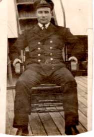

Black and white photograph of Alex MacDonald of Milton.
Alex MacDonald, skipper of deep-sea trawlers and brother of Captain Donald MacDonald of Milton, photographed in the late 1920s or early 1930s.
Black and white photograph of Milton House.
Side view of Milton House, probably taken in 1930s.

Black and white photograph of the MacArthur children of Milton.
The MacArthur family of Milton in the 1920s. L-R: Neil, Jessie Ann, Hugh Archie, Donald.

Black and white photograph of the motor launch used between Hynish and Skerryvore.
The teak motor launch in the process being built by a Chinese carpenter and Captain Donald MacDonald of Milton on board his vessel in the late 1920s early 1930s. It was used to take surveyors from Hynish to Skerryvore.

Black and white photograph of the MacArthur boys of Milton.
The MacArthur boys in Milton with their father`s boat in the late 1920s early 1930s. L-R: Donald (father of Iain MacArthur, Milton), Neil and Hugh Archie.

Audio cassette recording of Angus MacLean, Scarinish and Iain Fraser, School of Scottish Studies, on 24/8/1976.
Angus MacLean talks to Ian Fraser of the School of Scottish Studies on 24/8/1976 about the place names of Caoles and Milton. Tha Aonghas Mac ’Ill ’Leathain (Aonghas Dhòmhnaill Eòghainn Mhòir) a’ bruidhinn ri Iain Friseal o Sgoil Eòlais na h-Alba ann an Lùnasdal 1976 mun ainmean-aite a’ Chaolais agus Mhilton.
Ordnance Survey map, sheet NM04NE, 1:10,000.
Map of Vaul, Salum, Caoles, Milton, Brock, Ruaig and Kirkapol showing contour lines, roads and paths, boundaries, townships and buildings, bridges and cattle grids, rivers and drains, sites of antiquities, vegetation and rock features.
Ordnance Survey map sheet LXV.
Map of the eastern areas of Tiree from Baugh in the south to the Ringing Stone in the north, at a scale of 6 inches to the mile (1:10,560).
Ordnance Survey map sheet LXV & LXXIX.
Map of the eastern areas of Tiree from Baugh in the south to the Ringing Stone in the north, at a scale of 6 inches to the mile (1:10,560).
Laser print of colour photograph of the Milton road at Caoles.
The Milton road at Coales, probably taken in the 1950s.